Alexandria’s Duke Street: An opportunity for BRT, and a walk- and bike-friendly corridor
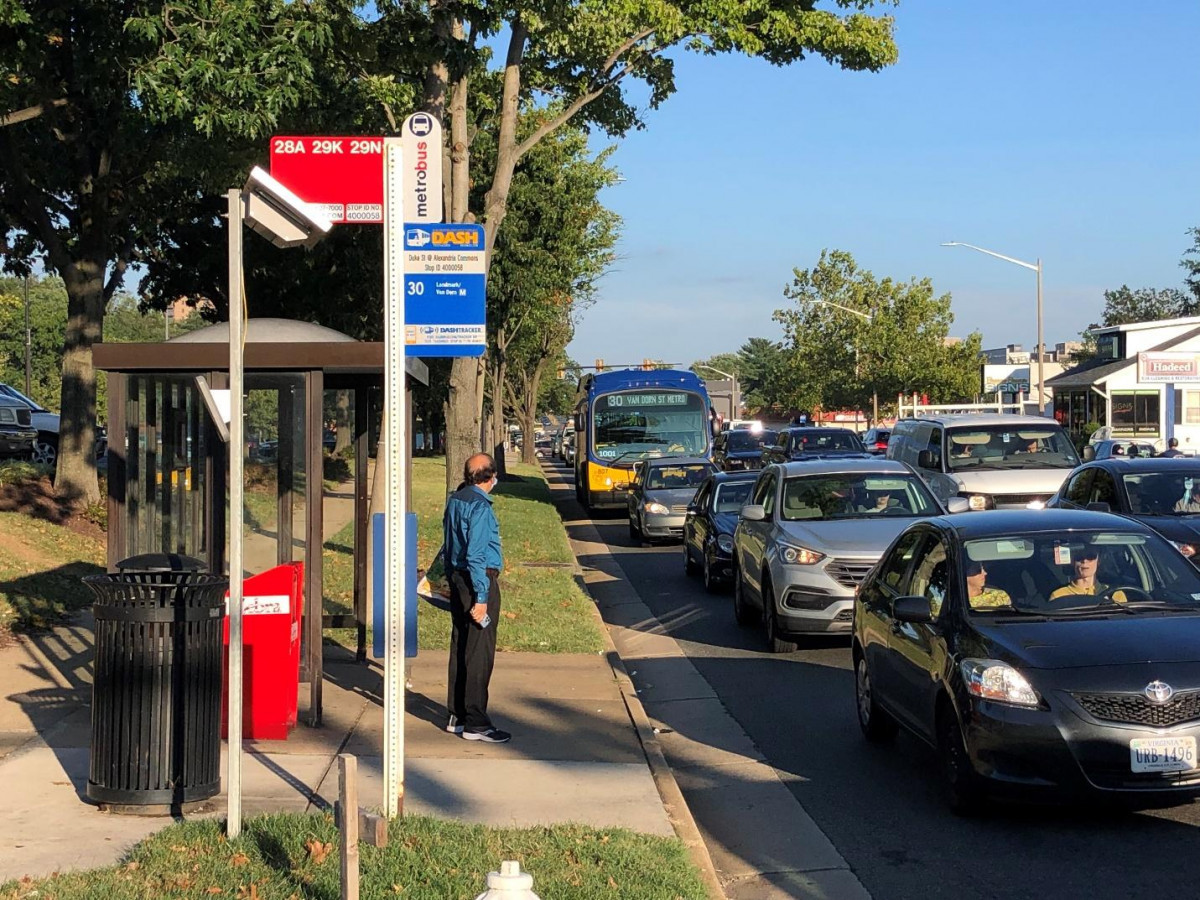
DASH #30 Bus on Duke Street, Alexandria, VA by Bill Pugh used with permission.
The City of Alexandria is engaging residents to improve transit and other transportation options along a four-mile section of Duke Street, an east-west corridor in Alexandria. In addition to carrying an average of 23,000 vehicles daily, the four-mile section is home to about 23,000 people.
Duke Street is the third of three transitway corridors first identified by the City of Alexandria in 2008. By June 2023, the “Duke Street in Motion” project will develop a Bus Rapid Transit (BRT) concept that also enhances the streetscape for people walking, biking, scooting and rolling. These improvements will support the walkable, livable, and equitable vision for the growing activity centers along Duke Street. Later this fall, the City will ask for public feedback on a menu of options. Here’s what you need to know.
Planned Duke Street Transitway (Yellow) as shown in the Alexandria Mobility Plan, City of Alexandria 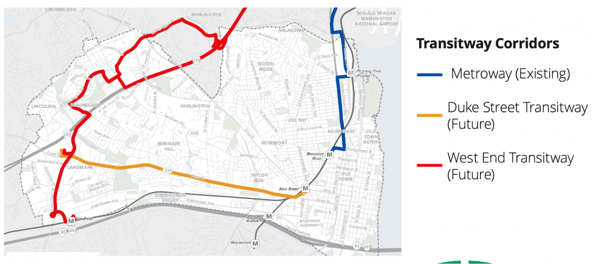
“Duke Street in Motion”
The Duke Street in Motion initiative covers a key four-mile corridor of neighborhoods, shops, parks, and city services, running from the Landmark Mall mixed-use redevelopment to the King Street Metro station. The corridor is diverse, with a mix of housing types, jobs and services, and many low- and moderate-income families and people of color. It is also a locally and regionally important bus corridor. Stakeholders made “Equitable” one of the guiding principles for the project.
Map of Density of Alexandria residents of color
DASH staff, using REMIX and 2020 census data 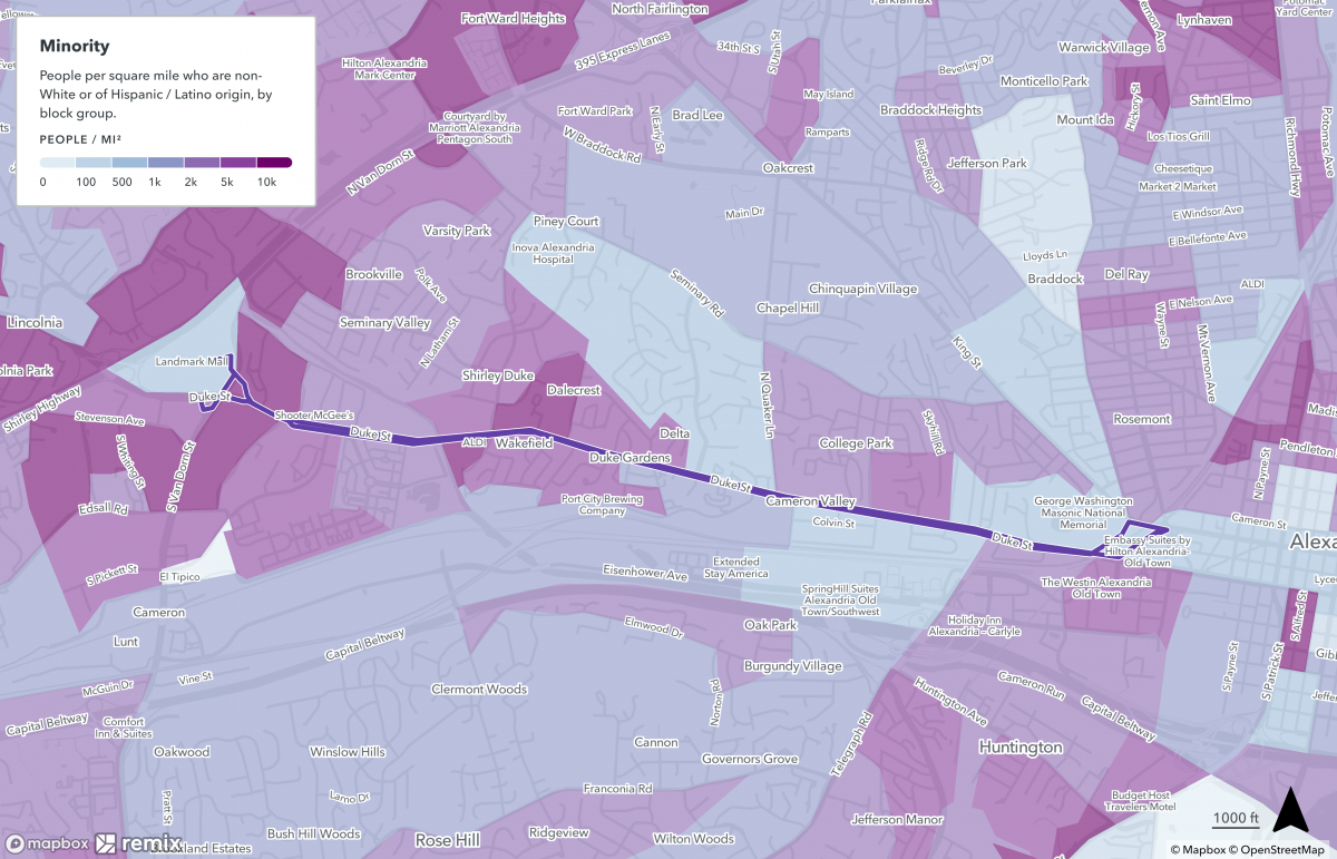
Map of Density of Alexandria residents in poverty
DASH staff, using REMIX and 2020 census data 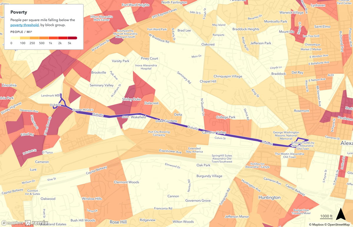
Successful DASH reboot
Alexandria has demonstrated the benefits of improved transit. Its DASH bus system has rebounded from the pandemic as a result of a redesigned network that increased the percentage of Alexandria residents near frequent transit (bus or train every 15 minutes) from 27% to 66%. This was accompanied by a policy decision by Alexandria to make DASH fare-free to support low- and moderate-income residents and workers. DASH is now exceeding its pre-pandemic ridership and has seen significant growth in off-peak and weekend riders.
The need for Bus Rapid Transit
However, several of Alexandria’s bus lines operate on streets with traffic congestion. Bus riders who take up very little precious road space must wait in lines of traffic at intersections and pinch points behind lines of cars and SUVs with typically one passenger each.
This is certainly the case along sections of Duke Street. As a result, a transitway along Duke Street has been in city plans since 2008. The current effort builds on the 2012 Transitway Corridor Feasibility Study, which recognized the need to create three spines of high-quality bus transit along the city’s dense urban edges. Enhanced and faster bus service will improve existing travel and accommodate new residents and workers in these growing and diverse parts of Alexandria.
Bus rapid transit (BRT) improvements are being implemented across the region and country, and while they vary from place to place, they ideally include dedicated bus lanes, off-board fare collection (or zero fare), bus priority at traffic signals, real time information, enhanced bus shelters, bike access improvements, and frequent service, resulting in faster travel times, increased reliability, increased access to jobs, and higher ridership.
Making Duke Street a great bus, walking and biking corridor
The targeted area of Duke Street today has four distinct segments: the eastern and western (1 and 3) have six lanes, and the middle (2A and 2B) have four:
Duke Street corridor segments by City of Alexandria.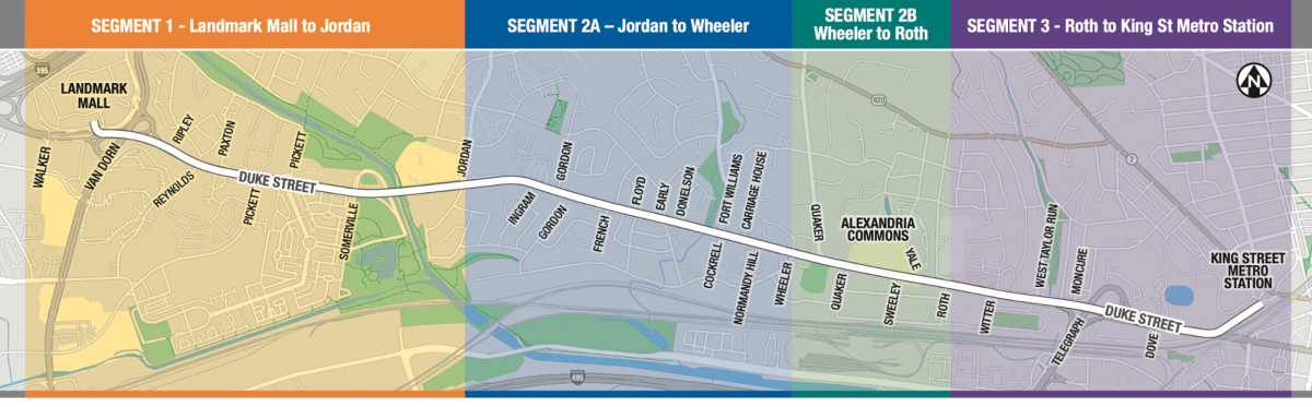
Two dedicated transit lane options are being considered for Duke Street’s Segment 1 and 3 for public comment: center-running transit lanes and curb-running transit lanes. Both options provide high levels of transitway reliability and comfort, and reduced travel times, compared to buses operating in mixed traffic. However, center-running transit lanes generally provide higher schedule reliability and shorter travel times compared to curb-running lanes, which encounter driveway curb cuts and intersections where they need to accommodate other vehicles making right turns.
Center-running lanes also enhance safety with shorter pedestrian crossing distances to/from a center bus stop, and use of dedicated left turn lanes and protected left turn signals for motor vehicles. Center-running lanes also provide more opportunities to plant trees and make other street-scape and environmental improvements.
Center-running bus lane example, Metroway, Potomac Yard, Alexandria by the author.
Segments 2A and 2B present design challenges, for example, four through lanes rather than six, and service roads. The project team is exploring additional options, including bi-directional transit lanes and hybrid options.
The Duke Street Transitway project is first and foremost a transit improvement project, but the project is also developing bicycle, pedestrian, and vehicular improvements in line with its Vision Zero and Complete Streets design guidelines. Options include cycletracks, widened and buffered sidewalks, a more continuous tree canopy, and/or multi-use paths along portions of the corridor.
Existing pedestrian environment along western segment of Duke Street with service road by Bill Pugh used with permission.
An important regional bus corridor
Duke Street serves not just travel among Alexandria’s busy activity centers, but also connects to two key travel corridors in Fairfax County – Little River Turnpike and Leesburg Pike. The corridor is part of Metro’s Frequent Bus Network. Combined with the DASH 30 bus route, these bus lines have attracted approximately 10,000 combined boardings per weekday, according to available data.
Metro’s network of Northern Virginia’s most important bus lines.
Note: map only includes high-frequency bus routes and does not show the extensive network of other Metrobus and local routes
Image by WMATA with author annotations. 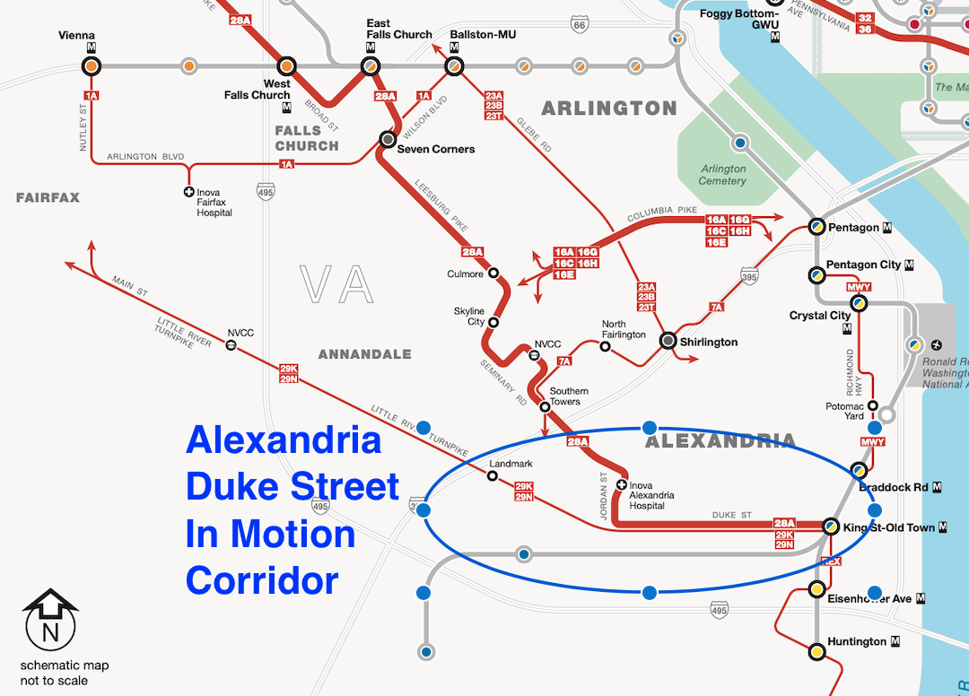
Managing vehicle traffic
The primary concern being expressed by drivers has been potential impact on traffic and driving. However, the bus has the potential to move far more people per hour interconnecting jobs, housing, healthcare, recreation centers and other services end-to-end in the corridor. In addition, the city has two current initiatives to manage vehicle traffic:
- Duke Street is one of the first two corridors in Alexandria that will benefit from signal upgrades through the Adaptive Traffic Signal Control project, which will allow signals to detect vehicles and automatically adjust signal timing to improve traffic flow.
- The Duke Street and West Taylor Run Project is addressing cut-through traffic on neighborhood streets and recurring traffic jams on eastbound Duke Street at West Taylor Run Parkway and Telegraph Road
But there is more that the city needs to do, specifically working with Fairfax and Prince George’s counties, to accelerate improvements to regional transit including the Richmond Highway BRT in Fairfax and the long-promised Metrorail across the Wilson Bridge (with uncongested lanes for buses in the interim).
The Duke Street study is an important opportunity to provide improved travel options, including dedicated bus lanes and safe walking and biking facilities, for a growing and diverse community. Visit the Duke Street in Motion project page to learn more, and provide feedback during public engagement opportunities in October.