Plans for “Dave Thomas Circle” get a missing crosswalk back; does it need more?

The Dave Thomas Circle Wendy’s by the author.
DC is moving closer to fixing one of its most vexing intersections, the triangle of New York Avenue NE, Florida Avenue NE, and First Street NE, which collectively surround a Wendy’s and have earned the nickname “Dave Thomas Circle.” Officials unveiled a new design for the intersection which includes some significant fixes to address resident and business requests. Meanwhile, some argue it could do more to prioritize people walking or bicycling.
How we got here
The intersection of New York Avenue and Florida Avenue had long been traffic-choked and dangerous, with bad and narrow sidewalks, long crossing distances, and lots of traffic. In 2010, the District Department of Transportation (DDOT) reconfigured the triangle into a “virtual circle,” where drivers headed east on Florida Avenue or making turns would loop around the triangular area.
It was far from a perfect solution, however. The area remained one of the city’s most dangerous, with 455 crashes from 2015 to 2017, the most at a single intersection if you count the three corners of the triangle as one. Getting between NoMa on the south (including the Metro station) and Eckington on the north was a chore for people whether on foot, bike, bus, or car.
The only real answer, DDOT planners said, was to remove the Wendy’s restaurant inside the triangle. Riffing on Dave Thomas, the Wendy’s founder, and Thomas Circle to the northwest, people informally dubbed this “Dave Thomas Circle.” Without the Wendy’s it would be possible to fit driving lanes and bike lanes in the street and, best of all, connect First Street directly to Eckington Place. DDOT created this design:
Image by DDOT.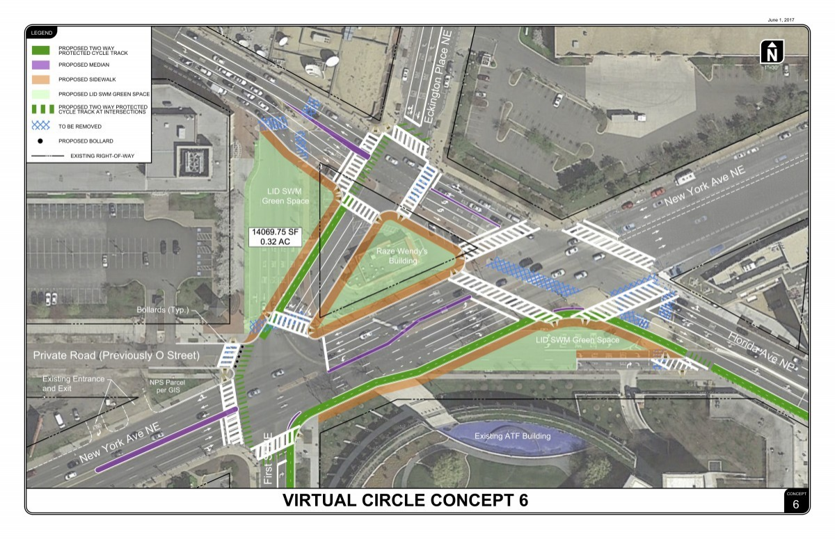
Leaders from the Eckington Civic Association, NoMA Business Improvement District, and others, as well as I, argued the design needed a few improvements. Most of all, that included no crosswalk on the east side of First Street crossing New York Avenue, and forced the protected bikeway on First to detour to the west side. People would have to cross at five crosswalks instead of two to traverse the area. The engineers argued this was the only way to “make it work” with their traffic models, but that’s an approach which puts car flow above all else.
Second, the intersection of New York and Florida avenues had huge numbers of lanes, and I worried it would resemble suburban mega-intersections like the corner of Gallows Road and US Route 29, which people at least used to have to walk through to reach the Mosaic District from the Dunn Loring-Merrifield Metro station.
Gallows Road and US Route 29 by Google Maps.
DC started securing federal environmental approval for the changes, which it has to get because the project affects federally-funded roads and affects the historically landmarked L’Enfant Plan (of which First Street is a part). May filings say DC anticipates a “Categorical Exclusion,” meaning this kind of project inherently won’t negatively affect the built and natural environment. There hasn’t been opposition to making this change in general.
Meanwhile, an Urban Land Institute panel studied the area and devised a design that prioritized through traffic less highly and did more to create a sense of place. The panel recommended connected east-west bikeways, and a First Street segment where the east and west sides felt more connected and which could be closed for special events.
Proposed design by ULI._800_537.png)
DDOT releases a new design
At a community meeting Tuesday, DDOT will be bringing community members a variant on its previous design, labeled Alternative 6D, which Gordon Chaffin first reported in Street Justice a couple of weeks ago. This improves upon the earlier design by restoring the crosswalk and bikeway on the east side of First Street.
Image by DDOT.
According to DDOT Director Jeff Marootian, the agency worked with the Federal Highway Administration to juggle many constraints in order to come up with a design that still avoided the “Level of Service F” failing grade which by customary traffic engineering practice isn’t permitted.
Conor Shaw, an area resident who runs a Twitter account Fix Dave Thomas Circle, says this design “is better than previous iterations in several respects,” including the connected crosswalks, making First two-way, and removing the entrance to O Street, which will just be a driveway to adjacent development instead of a through street.
However, Shaw said “major shortcomings remain,” and there are several areas he thinks the design should be changed further. He’d like to see an east-west protected bikeway through this area, since there is no other one in the two-mile stretch between K Street NE/NW and Irving Street, and DDOT has no plans for any bicycle facilities in that stretch.
He said “there are far too many turn lanes” which “gives the intersection a suburban feel.” And, he said the sidewalk should be widened on the north side of Florida Avenue through the underpass and on the adjacent block, where sidewalks “are extremely narrow” but the area is slated for large numbers of new residents and retail.
He also pointed out that the released drawings thus far don’t speak about whether DDOT would reduce speed limits and add red light or speed cameras, or implement the placemaking suggestions from ULI along First Street.
“DDOT is spending a ton of money to redesign an intersection for the second time in 10 years,” Shaw wrote. “It needs to invest in a facility that will serve us well for the next 30. The neighborhood is soon going to be one of the most dense and “urban” parts of DC. The design needs to fully embrace that future.”
Shaw mocked up this variant on the design, which reclaims much of the public space for sidewalks (orange) and bikeways (green):
Image by Conor Shaw used with permission.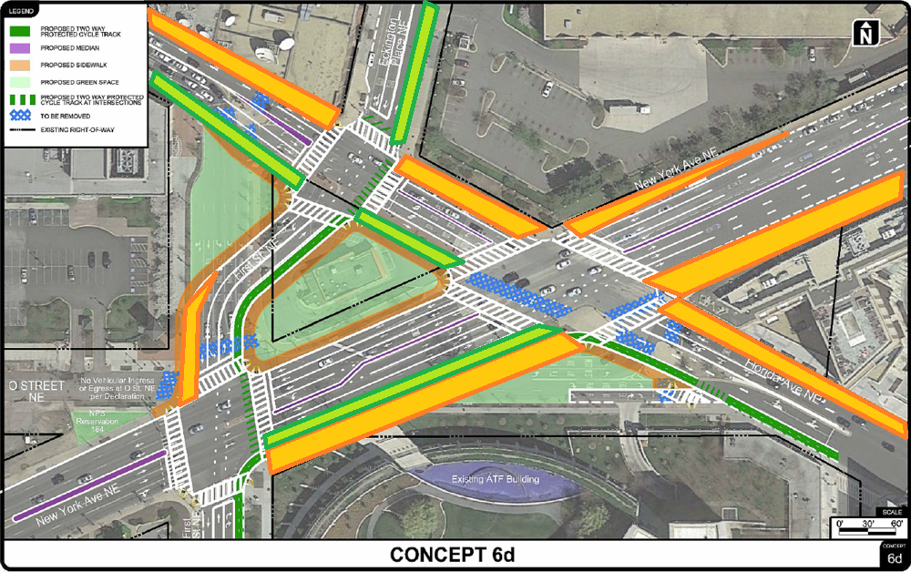
To these points, Marootian said that DDOT wants to leave the opportunity to add a bikeway on Florida Avenue and, similarly, a bus lane on New York Avenue. Either one would be a larger project than just this area, which is complex as it is, but they don’t want to preclude doing either in the future.
Regarding the public space design, he said, “The NoMa BID and NoMa Parks Foundation are partnering with DDOT and DDOT’s consultant team to inform the design of the open spaces. We hope that starting this collaboration during the design process will lead to high-quality designed, programmed, and maintained spaces.”
Marootian also argued that the numbers of lanes won’t feel like Fairfax County because, unlike there, there will be buildings and/or active public spaces right on the corners. A well-activated public space in the newly-created areas could do a lot to create a better feeling of connection across the space.
Ultimately, he said, these changes make something that’s very dangerous and forbidding to people on foot or bike much more pleasant and, most of all, safe, and the DDOT team says they feel this is a huge improvement.
What’s next
A project of this magnitude takes years, Marootian explained; that includes actually taking the steps to acquire the Wendy’s site. Under federal rules, if DC takes it by eminent domain there are procedures it has to follow to try to relocate tenants, which means, potentially another location for a Wendy’s.
DDOT hopes to reach 100% design by fall of 2020 and start construction in 2021. The construction would then take 12-18 months, so 2022 is the earliest residents, workers, and visitors could see a much different experience in this area than they do today.